
I think it's now safe to say that this is the third bad Summer in a row we have had here in the UK. If you live in Ireland, N. Ireland, or Scotland, then you will not argue with me. As has been the usual pattern recently August has turned out to be a wash out with the typical NW - SE split across the country. In S. Britain high pressure was producing hot sunny weather thanks to a feed of moist humid air advecting up from France, however In N. Ireland it was a different story with a low pressure system swinging past Ireland over the Atlantic Ocean and throwing numerous frontal systems over us. On August 18th it was a warm front, followed by two cold fronts on the 19th which produced extremely high rain totals. The second cold front which hit through the night on the 19/20th was extremely nasty with intense rainfall covering the entire country all night long. This was proper rain with the radar producing constant red returns.
The following day, Thursday August 20th, thunderstorms where expected to break out over Ireland and N. Ireland due to the unstable airmass in the wake of the cold front. Maximum CAPE values peaked at 900 with LI between -2 and -3 with E areas of NI showing the greatest instability during the afternoon and evening. There was decent wind shear and lift in the form of an E moving trough combined with solar heating. It was a classic 'thundery shower' day (I hate that term) and despite some restrictions to the set up ESTOFEX came close to issuing a level 1 risk for the chance of an isolated funnel/weak tornado event, although they did stick with the t-storm box for the official forecast. The convective maps showed a decent cool pool aloft with strong tornado and supercell parameters so it looked to be an interesting day.
By mid day I was checking out the radar and was delighted to see that thunderstorms had already fired up over SE Ireland, quite a few of them too, which was surprising for so early in the day although they did have strong instability at that time. The strongest instability would occur over NI at 15.00 or so. Looking at the radar I was disappointed to see no storms over N. Ireland at all, not even a single sferic which was disheartening. It was far from settled though due to clusters of showers in the W and midlands with blue and green radar echoes indicating light to moderate strength. I waited until the next update, which took a dreadfully slow 40 + min's, which showed those showers intensifying which was a good sign. A visual check on the sky showed weak convection, actually it was the kind I don't like at all and very similar to the kind of clouds we would expect to get in Winter in a classic polar maritime airmass. I didn't think the chance of storms were good at all based on the visual scene. This was the first chance of convective action I had since July so I couldn't help but feel excited, in fact I always think to myself (with each outlook) that while I'm sipping a brew in the morning, for all I know, in a few hours I could be catching my first tornado on the ground or see an amazing structure. That's the kind of thinking which keeps me going. My hopes were dashed though when I saw that rubbish cumulus out my window. So, feeling a little discouraged I checked out the various sites on the computer and messed around with other things in the house.
By early afternoon I decided that we should go storm chasing, besides, I felt like getting out somewhere anyway so would probably go for a drive to look around the country and memorize a few good locations for photography and have a nice walk somewhere, and if I seen anything cool in the sky then that would be a bonus so there was nothing to loose. It was a better plan than sitting in front of the computer looking at the radar all day getting frustrated. I get the gear together and check out the TV forecast which still warned of heavy thundery showers which I took to be a good omen. I opened the door to head out and got instantly blasted!. Out of nowhere an intense convective shower had arrived in from the W and dumped a phenomenal downpour of rain and hail with strong gusty winds which actually forced us back inside. The precip was completely horizontal and I watched with a smile on my face how it blasted against the front of our car and got redirected in various directions by the slope of the wind screen as if a power hose had been the source. It was quite intense and unexpected so we had to wait until it eased before getting into the car. Another good omen I thought.
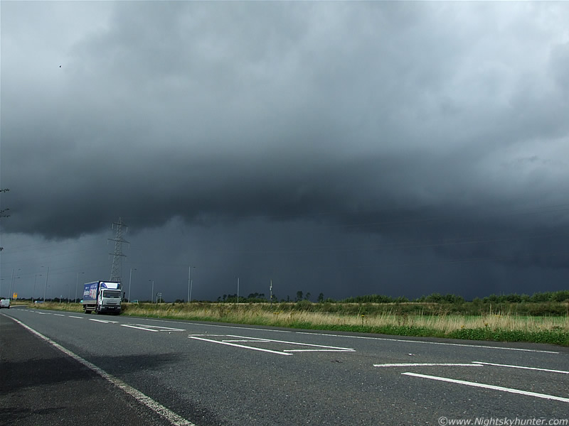
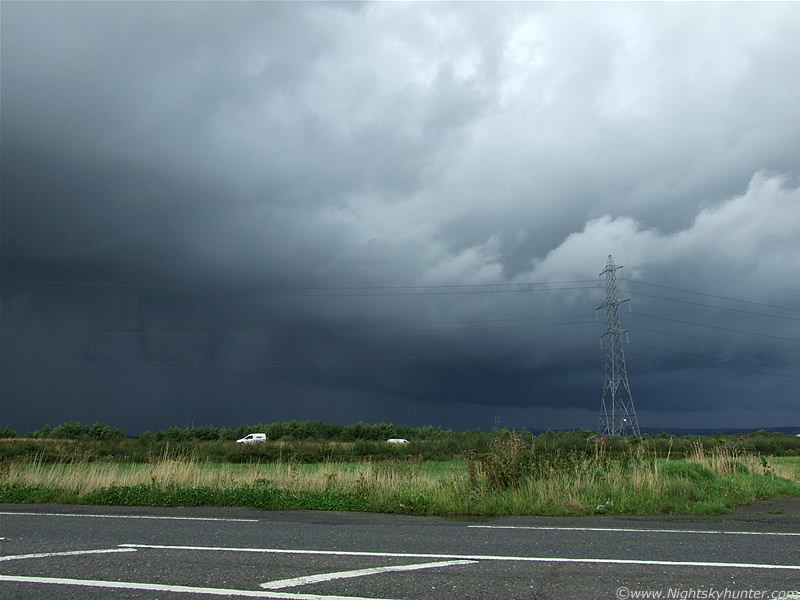
On the main carriageway between Maghera and Castledawson roundabout conditions really deteriorated in a big way with powerful down pours of horizontal rain and small hail driven by convective gusts of wind which made driving very treacherous.
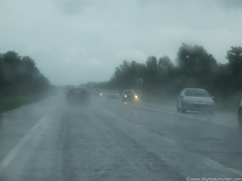 |
This is the view out of the front windscreen with visibility dropping in the rain. The sky turned pretty dark for so early in the day forcing drivers to use side lights then dipped head lights, although as is typical of people in this country, many didn't even bother when they should have. That really does annoy me because not only were road conditions bad but it was getting difficult to see any vehicle which didn't display any form of lights. You might think I'm exaggerating however the image above does not convey the scene faithfully because it looks brighter than it should. This, and the image below, required a fast shutter speed and higher sensitivity in such low light, along with trying to freeze the motion of cars, so these were taken at ISO200, something which I would rarely use in daylight.
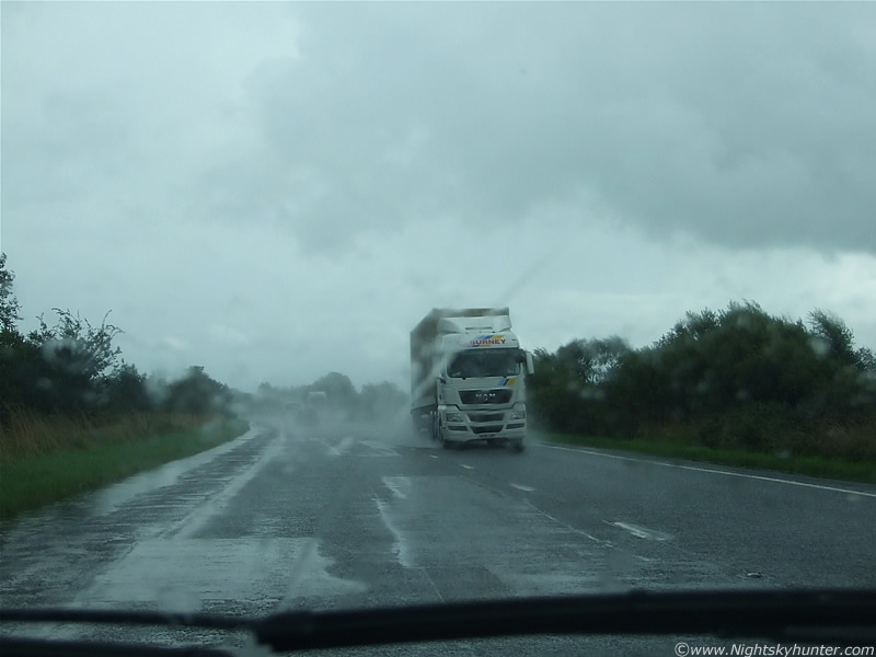 |
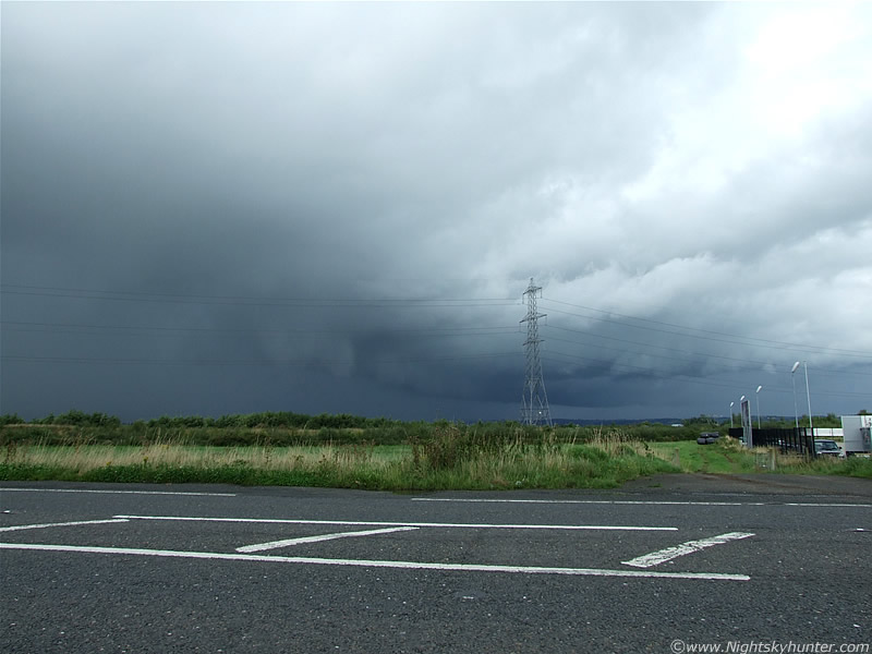
Still a complete downpour here however the brighter sky signals we would soon be exiting the rear of the cell. It was one of those strange days of warm sunshine and humidity contrasting with sudden showers and cold temps. As you can see the from the image the road sides where water logged on both sides. Passing trucks launched powerful waves of water which shook the car when they passed making it even more difficult to see. These intense showers combined with the cold front from the night before were just asking for trouble with water levels. We emerged into a bright clearance where I was hoping to see a funnel twisting above the road at the inflow area, but that was just asking for too much.
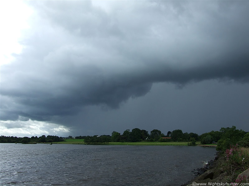
The plan was to head to Toome and see if any interesting convection was going up, then do a few messages and head to Lough Neagh and have a walk. The rest of the day's plan hadn't been figured out yet. The area between the Sperrins and NW Lough Neagh has become my favourite hunting area for convective events, I've had great success with it this year so I intend to stick with it in the future. I have some ideas about far W areas of the country and the N coast at certain times of the year for photo opportunities but that's all in the future. We arrived in Toome and while crossing the bridge I stole a glance at the River Bann to my R and was stunned by the impressive flood on show, actually it was absolutely shocking just how high the river had become since I had last seen it which wasn't that long ago. In fact, it was quite frightening in appearance so I made a mental note to take some images on the way back again (which I later forgot to do).
Still in Toome, plenty of cu towers are visible in the sky and they seemed to be gaining strength. The view in the rear view mirror showed a line of nasty looking cells between Slieve Gallion and E Sperrin Mountains in the SW and W heading in from miles away. It was very dark under there with strong precip so I had my hopes up for some action. It was moving E and would eventually arrive over Toome. We pulled off the main Toome line and entered an industrial estate to do a few messages and ended up bumping into a relative and spent quite some time chatting.
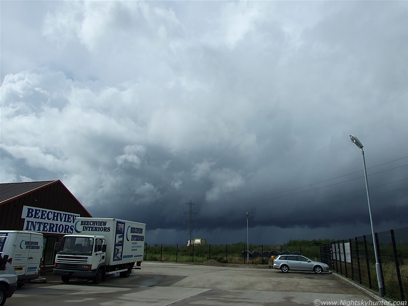 |
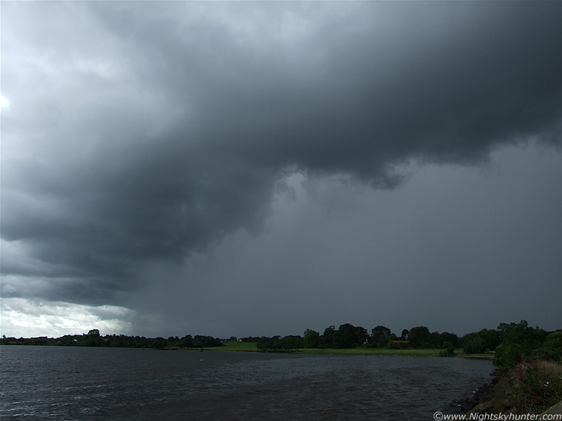
During the conversation in the shop my instincts were telling me something was happening and I felt a sudden rush to get back outside and get a visual on the sky, with time of greatest instability and solar heating approaching now would be a good time to catch the more vigorous convection. I was keen to see what had happened to that convective line over the mountains now. We walked back into the car park, looked W, and seen this nasty looking storm developing. I took this image through the open car window. The image doesn't do justice to how mean this thing looked with intense precip falling below and large updraught towers erupting up from the L with several large anvils visible extending out from the top. I wanted to get out and keep shooting it however the tall chain link fence was getting in the way, it felt claustrophobic so we got back in the car, drove out of the industrial estate, crossed the main Toome road, and pulled over into a perfectly placed lay by providing a direct view of the storm.
The S side of the storm looked awesome with actually scary looking curtains of rain falling from the very dark abyss underneath. I tried to get into a field (I'm always doing that) to get a better view however the barbed wire fence was not passable, plus the huge power lines messed with the photogenic potential. The Sun turned that side of the storm intense white which made getting an exposure extremely difficult, in fact, I couldn't even get a focus through the viewfinder due to the glare which was a nightmare. I got images but have since binned them. I needed a better angle so I went to the edge of the main road and set up the camera and tripod and began shooting.
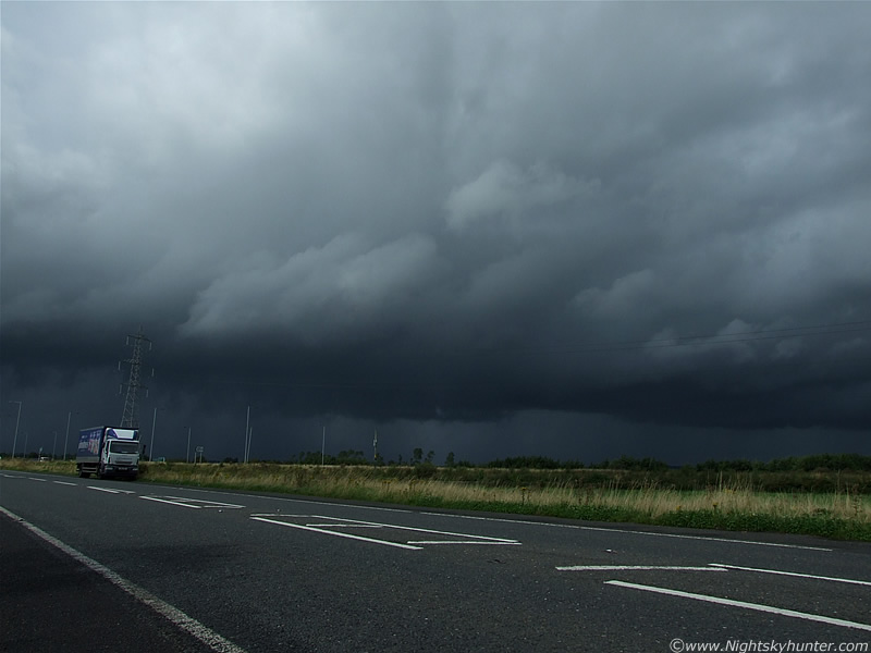 |
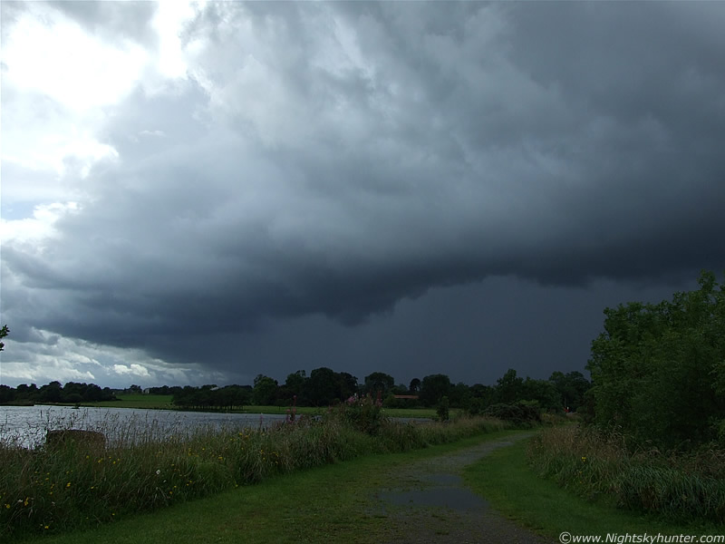
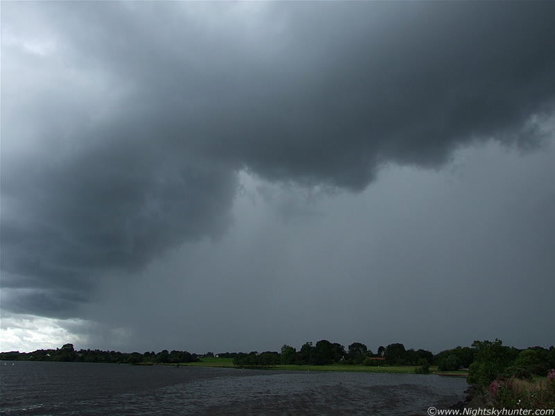
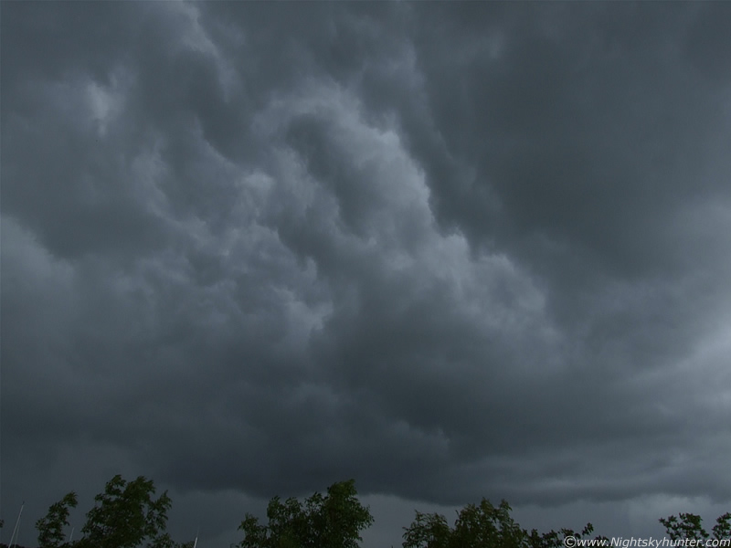
This was the impressive scene over the Toome Road looking W at approx 15.00 BST. This is the leading edge of the storm called the 'gust front' or 'shelf cloud' which marks the outflow region of the system. By outflow I mean where wind, lightning, and precip is produced. This guster was a mean sight, not only was it huge in size, it also hugged very low to the ground. The top section was bright where the Sun was hitting the anvil shield however the bottom was extremely dark, even black in places, there was even a subtle green colour in the precip. There was at least two cbs merged together and advancing forward to the E.
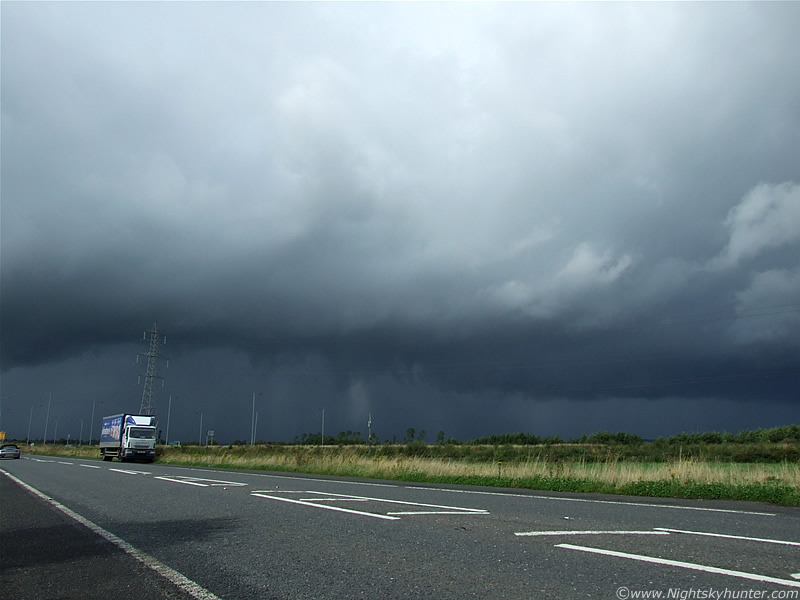 |
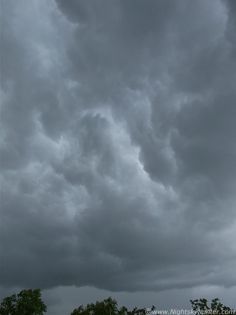
Gust front is moving towards me and to the R at the same time. Extremely intense rainfall was dropping from this with a pronounced radar signature showing a well defined N - S aligned series of red and white echoes which are the heaviest reading you can get. There was a mix of torrential rain and hail stones, the vertical white streak at centre shows a particularly strong hail shaft. I was drawn to the pointed scud hanging down from the shelf. This was such a great scene with glorious magnitude contrasts with the bright Sun illuminating the road and grass verges while the very dark storm lurked above. I got the usual strange looks from passing cars. I used a slightly longer shutter speed here to bring up more of the precip structure. Those huge pylons appear to be leaning over however that's just an effect from the wide angle lens I was using, which was at 28mm, all the images on this page were taken with that lens.
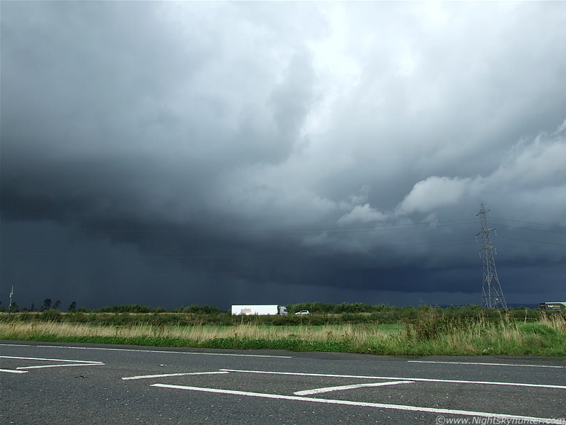 |
Moving R. A fantastic change in shape happened with the R side of the gust front developing a very pronounced slope. Underneath was a very well defined solid shelf like a horizontal metal bar which extended far away into the distance with precip falling below it for its entire length.
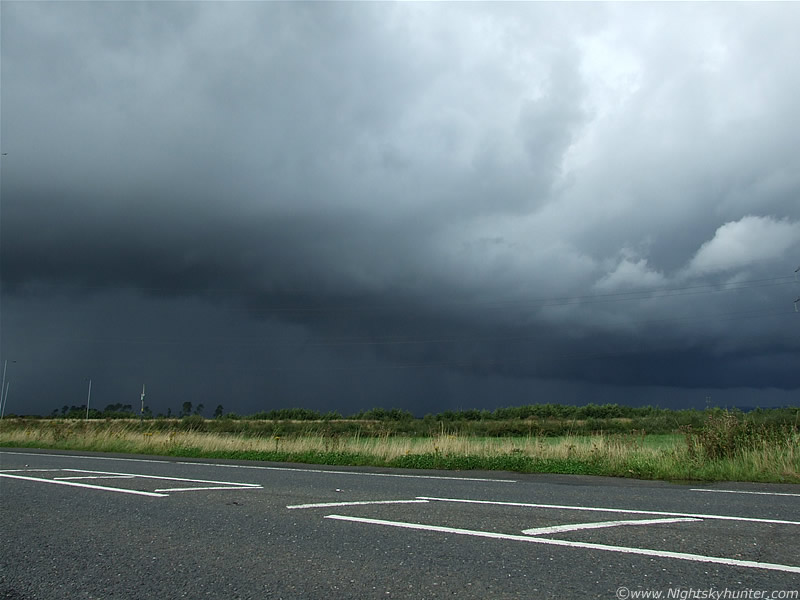 |
My Aunt was having tea in a cafe in Toome around the same time and informed me about the hail stones falling on the cars. If you are examining these images very carefully you may have noticed the very faint primary rainbow visible on the gust front which is evident on images 4 to 10. The outflow winds where blowing precip spray down range where the Sun caught them and formed that weak bow section. Actually, wind is a poor term, it was a squall, when it got closer I could see the straight line winds flattening the grass in rapid moving lines to the R.
 |
The mid section of the shelf is bowing out
 |
Impressive large chunky teeth visible to the L.
 |
Slightly overexposed but no matter. I was messing around with different shutter speeds to test how slow a shutter I could get away with in the hope of catching a still image of a c-g. I liked this image though because of the cool structure visible on the R in the form of a horizontal band of cloud extending forward from the storm behind the pylons. That band was huge and looked convective in itself. The structure to the L has became obscured by small hail falling from the anvil far above. That black fence to the R is the perimeter to the car park I was in for the first shot. We were just about to get blasted by the rain, hail, and squally winds so we got back in the car and drove SE ahead of it so that way I could stay out of the rain and keep an eye on the structure.
 |
Now the storm is chasing us. That's the S section of the gust front through the wing mirror. The motions under the gust front on that side were amazing with fast 'churning' patterns as if something was about to drop. Speeding ahead we found a side road which gave a parallel view of the storm and I could see multiple sections of turbulent motion and rotation from the dark rim hanging low over the bright green fields. This is not the primary place to expect a vortex however funnel clouds and weak tornadoes have been known to form on gust fronts produced by the outflow boundary, I thought I was going to get one but nothing dropped. Looking back on it now I wish I had taken an image of that line of turbulent clouds. The plan was to get far ahead of it then get out and image the approaching gust front for a second time however traffic was busy and the unpredictable roads had to be given full attention. When I looked back it was obvious the storm was on a more NE track instead of E so we lost it. From a considerable distance we watched it cross over the very N sector of Lough Neagh moving towards Antrim where it became electrically active and produced a decent amount of lightning. I was extremely satisfied at this point so if nothing else happened then at least I caught a very dramatic looking structure.
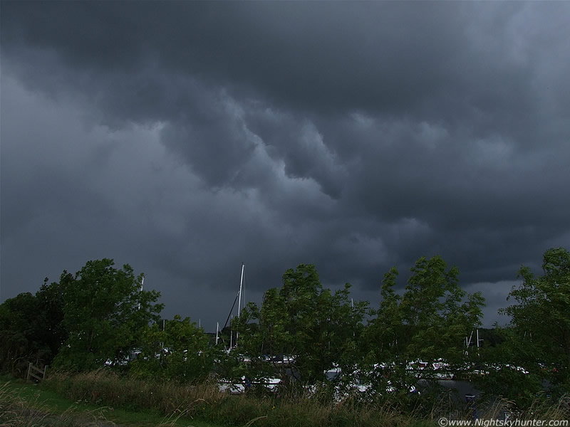
Time to move on. A powerful looking updraught tower with a solid profile was bubbling up nicely and was heading for Lough Neagh so we decided to head in that direction to watch what it did. We pulled into the car park at Ballyronan Marina on the NW shore of the Lough and watched but unfortunately the updraught died, so we went for a walk instead. I took the camera gear with me just incase. There where several long walk ways in the area that go out over the Lough surrounded by water on both sides with boats and yachts moored in the bay so I went out to the first one. From there I spotted a new line of convection heading directly towards me in the form of two large cells, each with a gust front, with intense rain evident. The N cell would pass by me however the S one looked like it was going to directly hit the Marina so while most people seeked shelter I decided to stay out because I wanted to experience it's force.
 |
This is the S cell with gust front fast approaching. I'm standing on the walk way. The open Lough is to the L and the bay is to the R behind those trees. You can see that the path is water logged. Even though the precip core is a respectable distance away I could already feel spits of rain hitting me blown horizontal through the air by the outflow. That was a sure sign of something strong about to happen.
 |
I moved over to the edge where large rocks and boulders provide a barrier to the waves. I stood on a bolder with a slanted top and with some frustration I managed to get all three legs of the tripod on top, although it was not fully extended in width. The front leg occasionally slipped off the rock so I made sure to have the neck strap on to stop the camera going into the water. Nice lip on that gust front.
 |
Very strong winds hitting me now and even the water is getting disturbed. The gust front was a menacing sight now. These are 28mm, the other half extends out of frame to the R.
 |
The outflow/down draught is so strong that I'm nearly blown off the rock, precip is flying through the air and I grabbed hold of the tripod tightly.
 |
I jumped off the rock because I didn't fancy a swim. That's the boats in the bay on the other side. This is the N (R) side of the gust front where very nice Whale's Mouth is visible under the shelf.
 |
This image extends from tree top height to almost overhead. The Whale's Mouth really was impressive, you will often see this kind of turbulent structure underneath a shelf cloud, in this case it's directly overhead and surrounding me like an umbrella.
 |
28mm vertical, moving L to R
Then the outflow hits me with brutal force!. I was genuinely shocked by how powerful it was because it was nothing short of a powerful squall which disturbed the trees with a concentrated long duration gust. The most amazing scene was the bow wave(s) racing across the surface of the Lough at high speed as rain and small hail lashed me and the camera. I was completely soaked in an instant, I felt like I had taken that swim after all. The rain beat the area hard then eventually crossed over me and moved over the Lough heading for Antrim. It produced lightning over E areas which the sferics charts recorded nicely. I watched that torrential rain curtain cross over the water with such force that I was quite overwhelmed. I would have to say that this cell produced the strongest outflow I have seen this Summer, even more than the massive multicell thunderstorms I had encountered in June and July, it would come second only to the severe squall line which hit Maghera during March. It was great to get on some good storm structures and experience nasty weather first hand. What shocked me the most was the dramatic drop in temp when that gust front hit, the air turned icy with a significant wind chill which reminded me of using the camera in Snow during the Winter, however this was Summer!. I really didn't expect this kind of action on this day so I was rather impressed. Just goes to show that you never know what you might see so it's always worth going out and keeping an eye on the sky.
Here's a short video clip showing the gust front over Toome and the above guster over Ballyronan. It's a pity video clips can't make the viewer feel the wind and the icy temp!, that sure was a shock to the system. I give this day the thumbs up, another good result for an already impressive storm season in N. Ireland. Looking forward to more.
Martin McKenna